The UK, rebuilt from open data

Real places.
Rebuilt in 3D.

VeriStreet is a pipeline that turns national open data into a working 3D model of a UK town. Streets, buildings, terrain and planting are generated from the data, not modelled by hand. Plan wireless and camera sites in it, see exactly what blocks a view and share the evidence.

PONTYPRIDD, WALESCaptured in VeriStreet on 16 September 2026Scroll to explore

One pipeline, any town

Open data in.
A working town out.

Every area starts from the same national datasets: OpenStreetMap roads, open building footprints, LiDAR elevation and OS address points. The pipeline compiles them into lanes, kerbs, roofs, facades, terrain and planting, then opens the result in the VeriStreet app.

Nobody hand-models a street. The same pipeline is built to generate any UK city; Pontypridd in Wales is the current showcase.

How it works
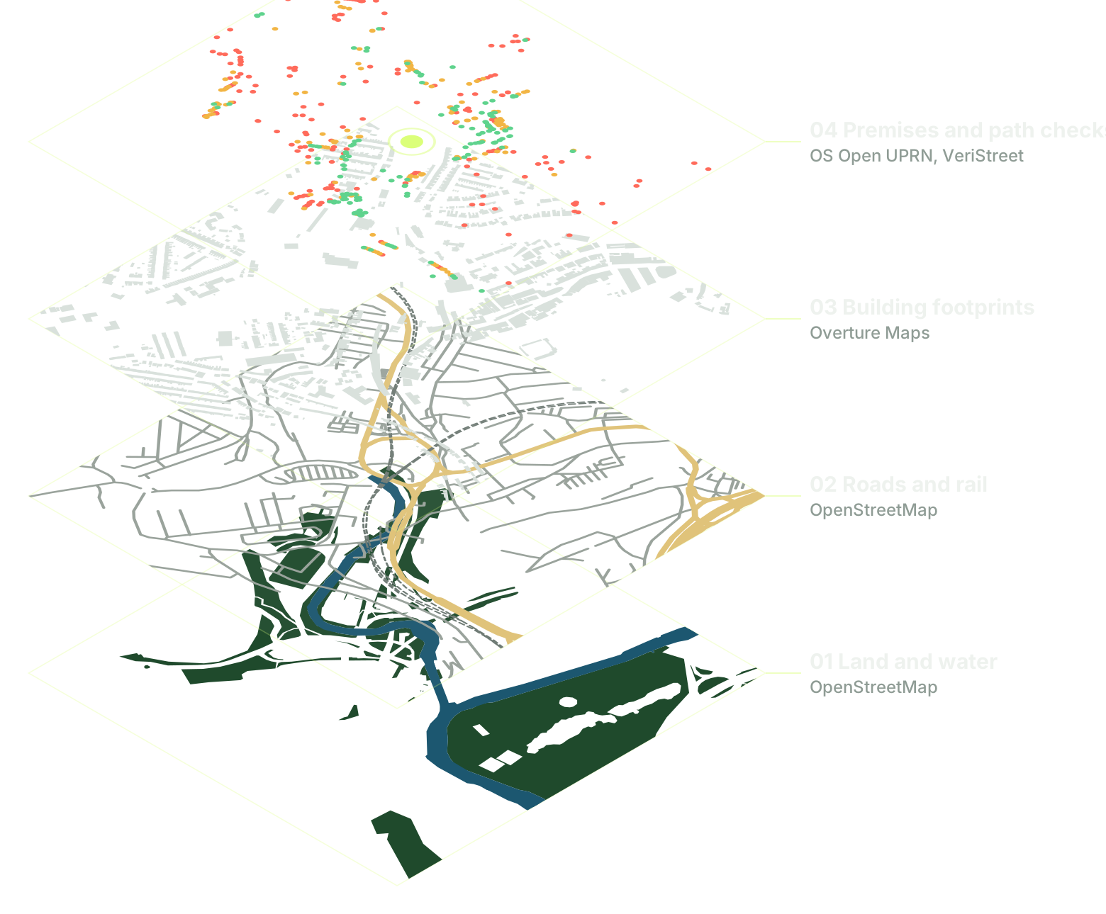
Four stacked map layers of central Pontypridd: land and water, roads and rail, building footprints, and premises coloured by path check result.
Central Pontypridd, one kilometre square: the real data layers behind the town, topped with August 2026 path check results.
A long stone terrace in Pontypridd in VeriStreet, seen straight on, with painted doors, sash windows, chimneys and a paved footway.
19 September 2026Terraced streets in Pontypridd, generated from open data.

Built for site decisions

Know what stands in the way
before anyone visits.

Fixed wireless and telecoms

A verdict for every premise.

Load your premises, place a candidate mast and run a path check. Each address comes back clear, marginal or blocked, with the first obstruction pinned on the map.

Then compare sites. In this Pontypridd check, moving the mast from site A to site B gives 193 premises a clear path and takes it from 54.

Wireless planning in the app
254 clear180 marginal284 blocked
393 clear168 marginal157 blocked
+193 gain a clear path54 lose one
Path check results for 718 Pontypridd premisesA map of Pontypridd with lines from a candidate mast to each premise. From site A, 254 premises have a clear path, 180 are marginal and 284 are blocked. From site B the figures are 393, 168 and 157. Moving from A to B gives 193 premises a clear path and removes it from 54.ABAB
August 2026 exportReal path check output for 718 address points (OS Open UPRN) in Pontypridd, from two illustrative mast sites at 32 m. Buildings, terrain and surface height decide each result. Geometric screening only: radio propagation, foliage, access and permissions are separate checks.

Cameras and ANPR

The best positions, ranked.

VeriStreet generates candidate positions along the road network and ranks them against the places you need to watch, with road width, distance and level constraints applied.

Each position shows why it ranked where it did and what is still unknown. Then step into 3D to check the view from the top picks.

Camera planning in the app
Ranked road-side camera positions in Pontypridd32 candidate camera positions on Pontypridd roads, ranked against 16 locations to monitor. The top position covers 9 of them within 300 metres. 321
Top five of 32 positions
RankPositionLocations coveredScore range
1Arterial road, 7 mGenerated on road graph9 of 1658% weighted49 to 74
2Arterial road, 7 mPlanning mast site A9 of 1648% weighted48 to 58
3Arterial road, 7 mGenerated on road graph9 of 1648% weighted44 to 69
4Arterial road, 7 mGenerated on road graph7 of 1648% weighted44 to 69
5Arterial road, 7 mGenerated on road graph6 of 1642% weighted41 to 66
12 September 2026Real output from VeriStreet's placement workbench: 31 positions generated on Pontypridd's road network plus one planning site, checked against road width, distance and layer constraints, then ranked. The locations to monitor are sample points. Field of view, plate reading, power, access and privacy assessments are separate.
Slate rooftops, chimneys, street trees and a crossroads of terraced streets in Pontypridd, seen from above in VeriStreet.
16 September 2026Roofs, chimneys, street trees and junctions built from mapped footprints.

Guided inspection

Pick a property.
See its front door.

Choose an address and VeriStreet frames that building from the street, beside its path check result. Positions, footprints and heights come from mapped data; facade details are generated to suit each building.

How the buildings are made
Front doors in red, green and cream along a stone terrace in VeriStreet, with sash windows and brick window arches.
Development build, 16 September 2026
Selected propertyUPRN 200003768159Obstructed
Match
Exact footprint
First obstruction
Building, 364.9 m away

Research

Teaching the pipeline
to read a street.

Maps show where a building stands. Street photographs show its door, its windows and its bays. We are testing image models that find those features and attach them to the right address, and every model is scored against hand-labelled Pontypridd streets before it can touch a building.

Inside the research
  1. A street photograph of Hurford Street, Pontypridd, with one house front outlined in yellow for analysis.
    1. Street photograph
  2. The outlined house front straightened into a flat, square view of its windows, door and stonework.
    2. Straightened facade
  3. The straightened house front with a facade model's labels overlaid: wall in green and mistaken door detections in red on sills and eaves.
    3. Model labels

Photograph: Hurford Street, Pontypridd, by Jaggery via Geograph, CC BY-SA 2.0. The straightened and labelled images are shared under the same licence.

Development journal

Since May 2026.

1,707 commits and 7 tagged releases since the traffic engine's first release on 10 May 2026, from lane-level simulation to a desktop app with 3D towns built from open data.

Private demos

Bring a real place.
Ask a real question.

See the current build with its creator, Evans Onomerike. Bring a site, a list of premises or a workflow you would like to try.